Hasta La Vista

Dominica

Dominica is dubbed the ‘Nature Island of the Caribbean’ and has the highest mountains in the Eastern Caribbean. The mountains, which act as a magnet for rain, serve as a water source for the alleged 365 rivers that run down the lush green mountain valleys. En route to the coast, many of the rivers cascade over steep cliff faces, giving the island an abundance of waterfalls. Dominica has the last surviving Carib population in the Caribbean and the absence of any major tourist developments.
Arriving in Portsmouth, a small town located on Prince Rupert Bay, three and a half hours after we left Isles des Saintes, we decided to anchor, clear into customs and immigration, and spent the next day in Dominica.
Before we had even entered the bay, a timber river boat with the owner’s name “Alexis”, clearly painted on the side, approached us offering us assistance with a mooring in the bay. We thanked him and declined. Once anchored, Alexis greeted us once again, giving us information on the location of Customs and Immigration, the local fruit market, the best restaurant and the tours that we could take while anchored off Portsmouth. “Indian River” was one of the tours offered. It is national park and no outboards are allowed. Alexis would pick us up in his timber dingy and row up the river, pointing out items of interest, and drop us back to Hasta La Vista an hour and a half later. We agreed to do the tour with him the next morning. Later that day, a local rowed out to us on his surf board, offering to buy fruit and vegetables or anything else that we needed, delivering them to the boat. Mal was happy to give one of the locals some business and ordered some mangoes, bananas and any other fruit going.
The town was not pretty, with dilapidated buildings for shops, restaurants and housing. The shore was scattered with large old rusty ships that had obviously been wrecked in a hurricane. Alexis confirmed this the next morning. In 1979, 75% of the islands buildings were destroyed by Hurricane David, however most of the damage in Prince Rupert Bay, was caused by three hurricanes in the early 1990’s. The beach disappeared and the sea now laps at the foundations of housing and restaurants that were originally located on the edge of a beautiful beach. As there was nothing to see in Portsmouth, we took the river cruise the next morning then motor sailed to Roseau, the capital of Dominica, where we anchored for the night, ready to sail the next day to the next island, Martinique.
The wreckage of one of the large ships washed up on the shore of Portsmouth, Dominica.
Our river cruise was interesting. Alexis had his cousin row while he pointed out things of interest and told us about his childhood growing up in the mountains. The river was overgrown with weeds and vines; small fish could be seen and small crabs scurried for cover as we moved along.
Old figs lined the shore, their roots creeping through the mud to retain their holding.

Concrete foundations for a train track that operated many years ago when the island grew sugar cane were located further up the river.

We reached a platform that led to a “forest bar”; no one was there, so Alexis led us to a friend’s plantation. Banana and fruit trees were scattered around in no order; there was a small vegetable patch but mostly the area was overgrown with weeds. Bare concrete buildings were the accommodation. It confirmed that the people on Dominicans are poor and tourism hasn’t got its grip like many of the other Caribbean islands.Alexis and his cousin in Alexis’s timber river boat.

Iles des Saintes

10km off Guadeloupe, eight small islands make up Les Saintes, the largest of which is “Terre-de-Haut” and the only small town “Bourg des Saintes”.
Bourg des Saintes is an adorable seaside town, sparkling clean and picturesque, with red roofs and a handful of those older Caribbean buildings that are all balconies and shutters. The landscape of volcanic hills and deep bays is strikingly beautiful. Flowers grow in abundance around the houses and no one is in a hurry. Local boats are anchored all along the waterfront. The island features beaches with good swimming and wind surfing, a fort with a botanical garden, and a large number of French restaurants. The roads are narrow and there are only a few dozen cars on the island. Motorcycles are the way to travel.
The town of Bourg de Saintes.
Village street of Bourg de Saintes.
Town Square, Bourg de Saintes.
Kerry in Bourg de Saintes.
Our stopover was for two days, the first of which, we cleared into Customs and walked the town as well as enjoyed lunch at a French restaurant overlooking the bay. Ongoing ashore the next day, we discovered that it was a public holiday and most shops were closed. However, the motorbike rental place was open, so we hired a motorbike and toured the island. Travelling the narrow concrete streets lined with brightly coloured houses, shops and restaurants, we visited the bays around the island and walked around Fort Napolean, the fort overlooking the town from high above it. We found a grocery store that was open and stocked up on a few fresh vegetables, milk and bread. Our afternoon was spent sitting in the cockpit of Hasta La Vista watching the yachts, fishing boats with their fishermen, and generally enjoying the beautiful sites.
The next morning, Thursday 28 May, we pulled up anchor and sailed to Dominica.

Guadeloupe

From Antigua we sailed to Guadaloupe and along the western coast of Guadeloupe in SE/E winds 15 – 17 knots completing 63 nautical miles in approximately 10 hours by the time we anchored off the capital city, Basse Terre, late afternoon. Guadelope’s western coast is mountainous and steep. There is plenty to see on Guadaloupe but we decided to anchor for the night and continue sailing to a group of islands, “Isles des Saintes”, the next day.
Lighthouse on Guadeloupe.

Antigua

Mal had visited Nelson’s Dockyard some 13 years ago on a quick visit to the Caribbean. He was looking forward to visiting the island again and had told me a little about Nelson’s Dockyard. I didn’t know what to expect but on entering English Harbour, I was absolutely enthralled. We both agreed that it is the prettiest place we have visited so far.
In 1723, work commenced on the English Harbour Dockyard, which would provide a port that was easily defensible, gave immediate access to the trade winds, yet protected enough to careen a ship and provide a safe haven in hurricanes. It was completed in 1745 and was Britain’s main naval station in the Lesser Antilles. Nelson was stationed here in 1784 and eventually took over as naval commander.
When former commander Vernon Nicholson sailed into English Harbour in 1947, the dockyard was in ruins. The arrival of Nicholson’s Charter Company in 1949 and the restoration of the ruins into a beautiful yet functional monument gave momentum to the development of the yachting industry here. The whole of Nelson’s Dockyard has been beautifully reconstructed and is now a restored Georgian Naval Base housing hotels, restaurants and businesses. It is not only the yachting capital of Antigua, but a major Caribbean yachting centre.
We were anchored in English Harbour while in Antigua. The harbour is quite small and is bordered by a lovely white sandy beach and resort; two hilltop forts flanking the entrance of the harbour, the largest one being Fort Berkely; and the restored Nelson’s Dockyard.
Fort Berkeley, English Harbour, Antigua, from the stern of Hasta La Vista.
View of Nelson’s Dockyard from English Harbour, Antigua.
Restored building in Nelson’s Dockyard, Antigua. The building was previously the Officer’s quarters and now contains a bar, restaurant and shops.
Forts sit on the hilltops surrounding and overlooking the Harbour. One of them, Shirley Heights, affords magnificent views of both English Harbour and Falmouth Harbour, which adjoins English Harbour by a narrow strip of land. The fort on the top of Shirley Heights has been partially restored and is now a bar and restaurant.


A view of English Harbour from Shirley Heights.

One of the less fortunate aspects of this harbour’s long history is that anchors occasionally get wrapped around 200-year-old artifacts, not least of which are several massive chains know as “hurricane chains”. As ships came into the harbour, their anchor would be dropped catching on these chains to slow them down and bring them to a holt.
Over 200 year old anchor with heavy chain attached, located on the beach of English Harbour, Antigua.

The road connecting Nelson’s Dockyard and Falmouth Harbour is lined with restaurants, but most have closed until November, when the “season” recommences. English Harbour has quite a few yachts anchored, most on their way south for the hurricane season. Falmouth Harbour and Marina, which caters for mega yachts, is basically empty with only a few vessels in the marina and a few yachts anchored in the harbour.
Our first day after arriving was spent exploring Nelson’s Dockyard through to Falmouth Harbour. On our second day, we hired a car. For the first time since leaving Australia, we drove on the left hand side of the road, in a vehicle with the steering wheel on the right hand side of the car!
Waters of different hues of blue lapped the coastline. The island was lush and green due to recent rains. The landscape was scattered with old sugar mills from times gone by. Sugar Cane is no longer grown. Resorts popped up occasionally as we drove along the coast. In between, there were small villages of brightly painted houses, vegetable stalls and small local restaurants. Wild goats roamed the green pastures and small farms scattered the island. St John, the capital of the island, was a small busy city with buildings tightly fitting the one way streets. There was no order to the city and parking was impossible. The highlight for me for the day was driving past the Sir Viv Richards Cricket Stadium. The stadium has been built quite a few miles outside of St John and stands amongst flat coast lands. It really is quite a site with its tiered stalls and the huge screen at the end of the cricket ground. It would have been great to watch a game of cricket. Perhaps next year.
Old sugar mill, Antigua.
Yes, I am just supervising Mal who took the photo of the old sugar mill!
Our last stop of the day was Shirley Heights. It was mid afternoon on a week day and being off season, the bar, restaurant and entertainment area was deserted. However, the views were amazing and the surrounding remains of the fort stood ominously on the point. We were told that Sunday Night, the bar and restaurant put on two bands and offered a reasonably price bar-b-q which attracts a large crowd. This is a very popular place with cruisers and tourists and is often featured in the Latitude and Attitude magazine. We went along on the following Sunday evening and had a great time!
The Sunday night crowd at Shirley Heights, Antigua.
Kerry enjoying the Sunday night evening at Shirley Heights, Antigua.
We had no idea that these islands are so dormant in the off season. But the weather is wonderful, 30 degrees during the day and 24 degrees at night. A swim at least twice a day is a necessity!
On Monday 25th May, after only six days in Antigua, we left for Guadaloupe. We had planned to stay longer, but with everything being so quiet, we decided to continue on and return next year in the high season. Also, the weather forecast indicated winds strengthening over the next week or so.

On our way to Granada
The hurricane season commences in June and ends in November. Many cruisers have insurance policies, a condition of which is that they must be out of the hurricane belt during these months. Granada south is the area to which they are all cruising. Even though our insurance policy does not have this condition, Mal and I have decided that we too, will sail to Granada and use this as a base during these months to explore Granada and the surrounding islands. Granada will be a very busy place and we are looking forward to our time there. Our plan is to sail to Granada during June and at the latest, July. There are many islands that we will sail pass or briefly visit on our way to Granada. At the end of this year and for the first half of 2010, we plan to sail north and spend more time exploring the islands which we passed or quickly visited.

St Martin/St Maartin

The Renaissance Islands include St Martin/St Maartin, St Barts and Anguilla. Their stable governments, sunny climate and spectacular beaches have led them into a startling economic and social rebirth. They are now major destinations for discriminating visitors who want fun and amenities, but enjoy them tinged with a certain degree of character and without too many high-risers.

St Martin/St Maartin is the smallest land mass in the world to be shared by two sovereign nations – France and the Netherlands. The northern part is French; the southern part Dutch. Of the island’s 37 square miles, 20.5 are on the French side and 16.5 on the Dutch. There is a charming story, completely unsupported by historical fact, that the French and Dutch were so civilised that, rather than fight over the island, they had a Frenchman armed with a bottle of wine walk in one direction and a Dutchman equipped with a flask of gin take the other. Where they met became the boundary, and the French ended up with a bit more because the gin was stronger than the wine.

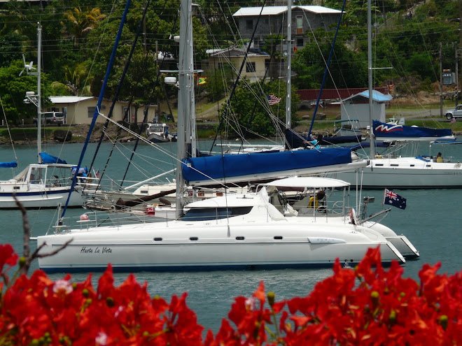
St Martin is the Caribbean’s major base for power super yachts, and many of the world’s most majestic private craft gather here for the winter. St Martin is also a popular bare-boating and cruising base.

The currency for the island is the Euro for the French side, the Netherlands guilder for the Dutch side and both sides accepted the US dollar.

We arrived at Marigot Bay, on the French side of St Martin, on Thursday 30 April after motorsailing twelve and a half hours from Virgin Gorda in the British Virgin Islands. The sea was relatively calm with light winds. We were accompanied by three small dolphins for a small part of the trip and for a short time, viewed whales in the distance.

Simpson Bay Lagoon is about 12 square miles of completely protected, landlocked water. Access is by a channel and lifting bridge from Simpson Bay. The next day we cleared into Customs and Immigration on the French side and motored into Simpson Bay through the afternoon bridge opening. The French/Dutch Border actually goes through the middle of Simpson Bay Lagoon so, because we cleared in on the French side, we anchored in the French Side. The borders are not patrolled and one can travel around the island and from side to side by car or dingy without any formalities. However, if one cruises between the Dutch and French sides or vice versa, one must clear out of one side and clear into the other!

The next two weeks were spent exploring the island and taking advantage of the duty free status of the island with purchases from the large chandleries and the many marine suppliers. We also located a French supermarket which provided delicious and inexpensive camembert cheese and a large range of other cheeses; a good selection of wines and a huge delicatessen offering fresh seafood and more. Mal and I enjoyed fresh rainbow trout, probably shipped in from France, for dinner a number of times. It was interesting that the supermarket did not offer shopping bags at the checkout. One has to provide their own bags and there is no other option. And we were required to punch in our pin number for the purchase transaction when we were using our credit card. This is the first time that we have been required to do this. In supermarkets on previous islands, we were asked for photo ID when we presented our credit card for a purchase. This is because credit card theft is so high in the US and the Caribbean.

There was a cruiser’s net on the VHF Monday to Saturday at 7.30am. A weather forecast was provided followed by helpful information on getting gas tanks filled, entertainment and coming events. We joined other cruisers for drinks and nibbles at one of the bars along the Lagoon on an organised cruiser’s night where we met some interesting people and socialised with old friends David and Jackie from “Jackster” who we met in the Dominican Republic and keep meeting along the way.

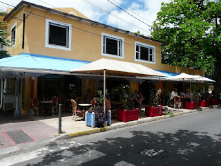
Marigot, the capital of French St Martin, has two commercial centres; the harbourfront, with its public market, souvenir stalls and ferry terminal; and Port La Royale Marina, a quaint area with higher-end boutiques and restaurants. The two are connected by a spectrum of shops and restaurants. We spent a number of days exploring the streets.

Souvenir stalls on the harbour front in Marigot (French side)

Port La Royale Marina, St Martin (The French side)

Street in Marigot (French side)

While exploring, we found a lovely French Restaurant which offered a light menu for lunch. It was so delicious that we returned another day. We also enjoyed dinner at a French Restaurant at the Port La Royal Marina one evening. It was wonderful to enjoy cuisine other than the “American style” fried foods which have been on the menus throughout the Caribbean until now. This time of year is very quiet, as it is the end of the “season” which is during the winter months. As we were walking from restaurant to restaurant, the owners or one of their staff were encouraging business by inviting people to come in to eat their delectable meals and offering a complimentary cocktail.

Among the shops at Port La Royale Marina, was a cigar shop that sold Panama Hats. Mal had been looking for a light, airy, brimmed hat since we first started sailing the Caribbean. He decided that the Panama was exactly what he was looking for!

Fort Louis which was constructed in 1767 by order of the French King Louis XVI to protect Marigot from marauding British and Dutch pirates. It’s been abandoned for centuries and contains only remnants from bygone eras. The fort overlooks Marigot and was included in one of our walks around Marigot.

Another day was spent exploring the capital of the Dutch St Maartin, Phillipsberg. The town is far more commercial than quaint. Most of the action is along the bay front road, which is lined with boutiques, jewellery shops, restaurants, casinos and duty-free shops selling everything from Danish porcelain to Japanese cameras and electronics. It is a major cruise ship stop and there are always plenty of people about.

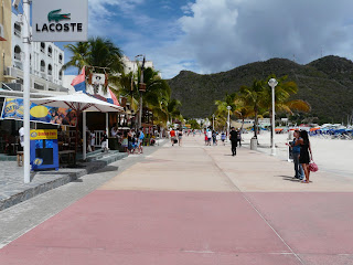
The esplanade along the beach front in Phillipsberg, St Maartin (Dutch side)

Back street in Phillipsberg, St Maartin (Dutch side)

Mal continues to complain about the work never ending on Hasta La Vista but he just can’t help himself!!! While we were at St Martin, he managed to install a new 80amp alternator in each motor; the foam in the helm seat was replaced; the weather covers were altered and we have a new rear cockpit black shade cloth. Mal also replaced the anchor chain and while the anchor locker was empty, painted it. Wandering the streets of Phillipsberg, we discovered and purchased a large Toshiba LCD screen. It is now fixed to the other side of the electrical panel and replaces the smaller LCD screen which we purchased when we first bought Hasta La Vista.

We hired a car for two days which allowed us to organise, drop off and collect the work that we had arranged and to travel around the island. The island is quite small. Because of the narrow rough roads, we didn’t travel to the top of the island where resorts and marinas fill the bays but cut across to the windward side. We discovered a butterfly farm and a riding school and agreed we would visit them on our next trip. As we drove along the coast, more resorts bounded the bays. We were going over a desolate hill wondering what the next bay would hold, when a very impressive marina and holiday resort came into view. It was midday so we indulged in a beach side lunch and a cold drink at a lovely little bar on the beach. Most interesting, while we were driving around the island, was the number of wild goats. They were everywhere throughout the island. Thousands of them!!


During the two weeks, while anchored in Simpson Bay Lagoon, the weather was wet with strong winds. We spent many days on “Hasta La Vista’ reading and relaxing and went ashore when the weather allowed. One of our short excursions was to the Cinema to see Julia Roberts in “Duplicity”. We hadn’t been to a cinema since Fort Lauderdale so we both really enjoyed the outing and the movie.


On Saturday 16 May, we cleared out of St Martin (The French Side) leaving Simpson Bay Lagoon through the Bridge on the Dutch Side to anchor overnight in Simpson Bay, and left early the next morning.

Our destination? – a short stay in Antigua, 130 nautical miles in a south easterly direction on our way to the Grenadines. When we pulled up anchor, we were not quite sure of the direction that we would take. We hauled the sails in Easterly winds of 17 knots and sailed most of the day in winds ranging between 17 – 25 knots. Our speed averaged approximately 9 - 10 knots throughout the day. “Hasta La Vista” was described as a “catamaran with a jet motor” by one monohull that we passed on the way! Our path to Antigua took us past four of the six islands that “Brush the Clouds” Saba, Statia, St Kitts and Nevis. Our direction didn’t allow us to view or visit St Barts, an island described as a little Paris in the Caribbean; Barbuda – a low island whose highest point is only 125 feet above sea level and with a mere 1600 inhabitants; or Redonda and Montserrat that two remaining islands that “Brush the Clouds”. Hopefully, we will be able to visit them next year.

We sailed past St Eustatius (Statia) (Dutch) – a small island with a large history; During the mid to late 1700’s, Statia was the trade capital of the Indies – goods were available here from all over the world; fine fabrics, silver, gold, household supplies, slaves, guns, sugar, tobacco and cotton. Today, there is only one town on the island, Oranjestad. And there is an oil-holding facility, so there is a constant stream of oil tankers going to and from the island.

And St Christopher (St Kitts) (British) – a green island with a dramatically steep central mountain range, much of which is covered in rainforest; In this photo, you can see an outline of an old fort, Brimstone Hill. British-built, it was captured by the French in a siege during which 1,000 British soldiers held out for some months against 8,000 French. Eventually, they arranged surrender with full honour. St Kitts, with its sister island, Nevis, became British under the treaty of Versailles in 1783.

Nevis (British) – an island that looks like a sombrero, peaked in the centre and low around the edges is where we anchored for the night. Oualie Beach provided us with a well protected anchorage and is said to be the most comfortable anchorage on the north-west of Nevis.
The following day, we remained anchored as heavy rain was forecast and the winds were predicted to ease later in the week. Our day was spent reading books and watching a DVD on our new large Plasma TV, which we purchased in St Maartin.
At 6.30am on Tuesday morning, 19 May, we pulled up anchor and motored to Antigua. Winds were from the south-east between 15 – 17 knots. We anchored in English Harbour, Nelson’s Dockyard, at 4pm the same day.

US and British Virgin Islands

We explored the US Virgin Islands (USVI’s) and the British Virgin Islands (BVI’s) for approximately two and a half months in total. We had the pleasure of having my Mother and Father stay with us on ‘Hasta La Vista’ for three weeks commencing the beginning of April. On arriving, our plans were to explore and become familiar with the US and British Virgin Islands before their arrival so that we could make the most of their time with us.

On his second voyage to the New World in 1493, Christopher Colombus encountered a very special corner of the Caribbean. Dozens of virtually untouched islands dotted the landscape – so many as a matter of fact, that he let his imagination go a bit wild and named them “Las Once Mil Las Virigines” after the legendary St Ursula, and the 11,000 virgins who, threatened by the marauding Huns in 4th century Cologne, sacrificed their lives rather than submit to a fate worse than death.

Located 18 degrees north of the equator and 1,150 miles from Fort Lauderdale, the island chain is close together and the islands themselves are high and volcanic, rising steeply from the crystal clear water. As with almost all of the islands ringing the Caribbean Basin, the Virgin Islands owe their existence to a series of volcanic events that built up layers of lava and igneous rock, creating islands with three geographical zones: the coastal plain, the coastal dry forests and the central mountains. Except where houses perch precariously on impossible steep slopes, the mountain slopes are dense subtropical forests. All of the timber is second or third growth; the islands were stripped for sugar, cotton and tobacco plantations, products of which they exported along with rum in the colonial era. The weather is reliably balmy with daily highs ranging between 25 degrees in winter and 28 degrees in summer. Easterly trade winds blow across the ocean from Portugal keeping the humidity lower than on most other Caribbean islands. There are no rivers and very few freshwater streams. If not for the desalination plants, the islands couldn’t support even a quarter of their population, let alone visitors. When a hurricane strikes, power and diesel facilities shut down. Islanders with enough foresight and money keep rainwater cisterns for such emergencies, but folks without suffer.

The Virgin Islanders hail from all over the world and fall mainly into four groups: the African descendants, the French (who emigrated from French Islands), Puerto Ricans, and the continental transplants from the United States Mainland in the US Virgin Islands and from the UK in the British Virgin Islands. Also “down islanders” from the southern islands of the Antillean chain and a sizeable number of East Indians. Blacks outnumber whites by more than four to one. The descendants of former slaves, Blacks now dominate the political and professional arenas on the islands.

The USVI’s are an unincorporated territory of the USA. All citizens of the USVI are US citizens, but they cannot vote in presidential elections. Though the USVI wear a veneer of mainstream American culture, with conveniences like shopping malls and fast food, West African culture is a strong presence. The US archipelago consists of about 50 islands of which there are three main islands, St Thomas, St Croix and St John. St Thomas, where the capital of the USVI’s, Charlotte Amalie is located, has a population of 60,000 people and is just 19km long. Where St Thomas is loaded with homes and businesses, St John is largely wilderness with almost ¾ of the island being National Park. St Croix is 64km south of the other Virgin Islands and is distinctly “relaxed”. The island turns to industry as well as tourism. The Hovensa Oil Refinery on the south shore is the fifth largest in the world. Most of the oil comes from Venezuela, is refined and exported, along with sulphur and other by-products.

The BVI’s is largely autonomous, covers 59 square miles and comprises of over 50 islands, islets and cays, many of which are uninhabited or sparsely populated. There are four main islands in this idyllic group, the largest of which is Tortola (‘Turtledove’ in Spanish) with a population of 23,500. It is the centre of the territory’s commerce and Government. Virgin Gorda (The ‘Fat Virgin’) has a population of 3,900 and is the next largest island in the chain, followed by Jost Van Dyke, and the BVI’s only coral atoll, Anegada, with about 300 people on each.

The history of the Virgin Islands is woven into a rich tapestry of tales! Since their discovery, the Virgin Islands have been governed by seven different nations: Spain, England, Holland, France, Knights of Malta, Denmark and the United States. Proximity to major trade routes, numerous safe anchorages and availability of supplies made conditions for piracy ideal during the late 1500’s, early 1600’s. Pirates are thought to have made port in the Virgin Islands to repair and supply their vessels. Around 1595, the famous English privateers Sir Francis Drake and Jack Hawkins were using the Virgin Islands as a staging ground for attacks on Spanish shipping. In 1682 the French pirate Jean Hamil captured the merchant vessel La Trompeuse. Then there are legends, the most famous and colourful being Edward Teach, better known as Blackbeard. Blackbeard’s Tower, located directly above Charlotte Amalie, was built in 1689. Another so-called buccaneer stronghold was Bluebeard’s Tower, also located directly above Charlotte Amalie. The islands are scattered with the remains of forts, sugar mills, rum distilleries, and slaves’ living quarters. The pirates’ towers of Blackbeard and Bluebeard are in very good condition and are major features of the Charlotte Amalie landscape.

Our stay in the Virgin Islands lasted ten weeks and during that time, we explored most of the main islands and anchored off many the smaller islands. Here are some of the highlights of our time there.


Charlotte Amalie, St Thomas, US Virgin Islands

Named after a Danish Queen, Charlotte Amalie is the capital city of the US Virgin Islands and a major seaport. It is the most popular cruise-ship and duty-free destination in the Caribbean with more than 1000 cruise-ship visits per year. Every day, thousands of passengers flood the 78 sq km island. The town has many of the original Danish buildings and mansions on the hillside overlooking the harbour. Picturesque alleys and stairways lead from one street to another. From the harbour’s edge, the town buildings, whitewashed with red-hipped roofs, spread across the narrow coastal plain and blossom over a cluster of pointed hills.

Blue Beard’s Tower, Charlotte Amalie, St Thomas, US Virgin Islands.

Blackbeard’s Tower, Charlotte Amalie, St Thomas, US Virgin Islands.

While in Charlotte Amalie, we found the 99 steps which were constructed using ship-ballast brick in the mid 18th century. The stairs lead to Blackbeard’s castle. In the 18th century, this five story masonry watchtower was allegedly the lookout post of pirate Edward Teach, alias Blackbeard, who found St Thomas a useful haven from which to ambush unsuspecting merchant ships. From there we visited Haagensen House, a restored 1830’s town house holding a small museum that splendidly evokes Danish colonial life and other historic houses as well as the World Amber Museum and a store offering authentic coins discovered in ship wrecks.

Mal and Kerry at Black Beard’s Tower, Charlotte Amalie, St Thomas, US Virgin Islands.


We took advantage of our time in the Virgin Islands and hauled ‘Hasta La Vista’ out at Nanny Cay, Tortola, BVI’s. We lived on board for five days repairing and painting her bottom. The topsides were polished and the mainsail shortened.

Tortola, British Virgin Islands.

Road Town, the capital of the British Virgin Islands, is the centre of commerce, shipping and social activity. Over the past decade, tremendous development has taken place to enable it to better cope with the steady influx of cruising and charter boats.

A quiet back street, Road Town, Tortola.

Mal and Kerry at a marina restaurant, Road Town, Tortola.

The best-known bar on Tortola for many years is Bomba’s Surfside Shack. It is literally a shack built from nailed-together beach refuse, with signs that challenge ‘sexy’ females to get naked. Apparently this has worked, as the bar’s decor consists of ceilings strung with bras and panties.
Bomba’s is famous for its monthly full-moon parties, which features an outdoor barbecue, live reggae, plenty of dancing and drinking. Bomba serves free psychoactive mushroom tea and up to five hundred people show up for the parties. We were told that a lot of women look back on their experience at the Bomba Shack with horror and regret their poor choices they made under the influence of mushrooms and rum punch.

Cane Garden Bay is regarded as one of the more beautiful anchorages in the BVI’s. We anchored off Cane Garden Bay many times, explored the area and enjoyed the many bars and restaurants overlooking the water.

Callwood Rum Distillery, Cane Garden Bay, is the oldest continuously operated distillery in the Easter Caribbean. The Callwood family has been producing Arundel rum here for generations, using copper vats and wooden aging casks.

Beach Bar, Cane Garden Bay, Tortola.